BROULEE MOSSY POINT COMMUNITY ASSOCIATION
  • Home
  • About
    • Newsletter
  • Events
  • News
  • Links
    • Art on the Path
    • Broulee to Breakers Ocean Swim Photos
    • Sand Modelling Competition >
      • Sandcastle 2014
      • Sandcastle 2015
      • Sandcastle 2016
      • Sandcastle 2017

High Rise - 90-92 Smith St - Submission notes

5/2/2023

0 Comments


Make a submission

Thank you to the Eurobodalla Shire Council General Manager Warwick Winn who attended last weeks public meeting with the more than 200 members of our community.

For all those who attended it is critically important to write a submission if you have any concerns about this proposed development. It is important to keep your objections related to relevant planning matters and where possible refer to the relevant planning

One of the key objections raised in the meeting was that the proposed 4-story buildings of the development significantly exceed the maximum building height of 8.5m as defined in Clause 4.6 of the Eurobodalla Local Environmental Plan. The developer is seeking to get a variation on the building height which would set a precedent for other developers to also exceed the height.

How to make a submission:
Submission close Monday 13th Feb
The easiest way to make a submission is to press the "Lodge Submission" button on the Council’s DA tracker for this specific development.
​
if you wish to make a submission via post or email your submission should contain the Development Application number. It must contain your name, postal address and signature, as well as your telephone and email contact

Application ID DA 0391/23
Property Lots 8 and 9 DP31071, 90 – 92 Smith Street, Broulee NSW

Address to:
General Manager
Eurobodalla Shire Council
PO Box 99
MORUYA NSW 2537

Email: council@esc.nsw.gov.au
-----

Submission Notes

For those who are interested in reading some further detail, a talented member of our community Owen Abbott from Owen David Architecture kindly shared his notes relating to all the technical details. They are made available in good faith and as guidance in making submissions and do not constitute planning advice.

Council Links

The relevant links:

DA Application: (development proposal documents)
https://eservices.esc.nsw.gov.au/T1PRProd/WebApps/eProperty/P1/PublicNotices/Public NoticeDetails.aspx?r=ESC.P1.WEBGUEST&f=%24P1.ESB.PUBNOT.VIW&rf=P1.ESC.PUBNOTAL.E NQ&ApplicationId=DA0391%2F23&fbclid=IwAR0MeeZTwLCEBmIK6xtYgI6YPLx- _ycgQoC5uZDVy1eLmbcA_KvADexO8AU

Eurobodalla Residential Zones – Development Control Plan:
https://www.esc.nsw.gov.au/__data/assets/pdf_file/0003/135255/Residential-Zones- DCP.pdf

Eurobodalla Local Environmental plan 2012:
https://legislation.nsw.gov.au/view/html/inforce/current/epi-2012-0333#statusinformation

The Developers Documents

Perhaps you are interested in reading why the developer feels they should be exempt from the rules that apply to everyone else?

Amazingly one of their key arguments is that they need to put in a 4th story on these building so the top floor can act as "private space" for the residents. We feel that if they reduced the number of buildings they are trying to squeeze onto block then there would be adequate space for them to include private space and keep the buildings within the 8.5m height limit.

They also feel the development will bring "affordability" to housing in Broulee and "seeks to maintain the coastal village feel enjoyed by Broulee residents" and that the nine 4-story units have a design that is "an interpretation of the coastal boatshed"??? They feel the development is consistent with a Low Density Residential Zone.
​
This document is the Developers rationale as part of their submission for being granted an exemption to the 8.5m height limit with some key sections highlighted.

Broulee Community Association Draft Submission

We don't envisage that everyones submission will be this long and we would stress that a short succinct submission is better than none. 

Attached is a draft of our Submission

​
0 Comments

High RIse in Broulee - Council Response to Questions

1/2/2023

0 Comments

 
Hi Andrew,

I have been observing the issues and concerns arising with the DA on exhibition for 92 Smith Street, Broulee. Thank you for the invitation to your community meeting. I will be coming tomorrow.

I thought it would be useful to forward a copy of replies to a series of questions just sent to Councillors. I look forward to meeting you tomorrow evening and hope the questions and answers may address some queries you may have received.

I am new, so still getting a feel for these matters here in the Shire. Some of the questions indicate a bit of a misunderstanding of the actual process (e.g. Council cannot just reject an application because we, or the community, don’t like it. There is a process we must follow.).

Also this issue of people not being informed. Council writes to the registered address, of adjacent and adjoining properties, where the rates go to. I get a feeling, and I may be wrong,  that people are suggesting Council is keeping them in the dark. That is not the case.   

Don’t hesitate to call me for any clarification. See you tomorrow.

Warwick
0 Comments

DA Letter to Councillors

26/2/2022

0 Comments

 
Dear Mayor and Councillors,
Broulee 80 lot subdivision
This 80 lot subdivision DA currently before Council is the final and largest subdivision stage of this proposed development in Broulee. It will have a major impact on the local community and the local environment. 

There have been many thoughtful submissions to Council on this DA application. However, it seems likely that the DA will be processed under the current delegated authority assessment regime and there will be no further debate on the serious issues raised by the community. For all practical purposes the community will learn the outcome of their submissions when the bulldozers start-up.

We believe there is a need for Council to respond to the community on at least the major issues raised and the outcome of Council’s consideration of them. The BMPCA is seeking a meeting with Councillors, Council Planning staff and perhaps the developer to to get a better understanding of Council’s reaction to the serious suggestions made by the community. If Council is making a summary of the community submissions perhaps this could form an agenda for the meeting.

At this stage we are not proposing a large meeting but a smaller group of perhaps five community representatives, Council planning staff and Interested Councillors.

Another way of developing an agenda may be to consider to what extent this development can meet general requirements for good development. This would include issues such as:
  • Protection of public land that is currently used for sports, passive recreation and interaction between the community and the natural environment.
  • Road design that does not take priority over pedestrians, cyclists.
  • Design that considers the future impact of climate change.
  • Impact on the local community. Does the development fit with the existing village structure of Broulee. If not, does it have to be radically different to achieve the objectives of the Council and developer? 
  • Has protection of the environment and the implications of the design for community health and social wellbeing been properly taken into account
  • Does the new development preserve existing community values and natural infrastructure such as clean and attractive beaches?

On behalf of BMPCA and the wider community I am asking Councillors for their support for a meeting with the community to allow Council to respond to the major issues raised by the community.
​

I have attached a copy of the submission made by the BMPCA to provide some more context but I know individual members of the community have made important submissions raising issues not covered in the BMPCA submission

Yours sincerely,
Andrew Bain
President BMPCA 

0 Comments

Summary of Petition Results

24/9/2021

0 Comments

 
A quick update on the current status of the Community land on the corner of Clarke Street and Broulee Road. There was a briefing of Councillors on last Tuesday by Council staff. This included the issue of the community land. The Community Association put together a summary of the petition to date and we sent it to all Councillors on Monday.

The full letter is attached below and the key statistics are:
  • 245 of the 410 respondents were from Broulee/Mossy Point
  • Respondents came from 24 different Eurobodalla suburbs
  • Of the 48 streets in Broulee, residents from 36 streets signed the petition
  • The clear reason why people signed the petition was that Council should follow through with its previous commitment and retain the important vegetation by reclassifying the land as Community Land. 
  • 76 respondents of the e-petition left additional comments
  • We asked respondents of the e-petition to list their household size. The average household size of Broulee/Mossy Point respondents of the e-petition was 2.5. Which if you extrapolated out to include partners and children would indicate 600+ Broulee and Mossy Point residents support this petition.

The head of Planning at Council, Lindsay Usher, telephoned the Association acting-president, Andrew Bain, on Wednesday and confirmed the matter will go to Council at the meeting on 12 October. Four options will be offered for Councillors to choose from. Council staff will apparently not make a recommendation but we assume there will be costs and benefits of each option presented. He did say that at the briefing there was some sympathy expressed for the community view.

We are not sure whether the Council meeting on 12 October will be a zoom meeting or not. Regardless we think we should try and get as many people to the meeting as possible. We will find out what the rules are for public participation at a zoom meeting and let everyone know.

You can still sign the e-petition here on our Google Form: https://forms.gle/T16zistVTzrdTzp3A
0 Comments

Community Land History

30/7/2021

0 Comments


Save remaining vegetation on Community Land
On the corner of Broulee Road and Clarke Street
History and where we are at

In 2003, Eurobodalla Shire Council (ESC) was reviewing the Plan of Management for its Community Land (reserves). It sought comment on the future use of land at the north western corner of Broulee Road and Clarke Street, Broulee, claimed by Council to be Operational (land which Council can use in performing its functions or can sell as an asset).
At the time, the President of the Broulee Community Association presented to Council saying the “overwhelming wish of the Broulee community” was to retain the land as bushland.

Subsequently, the Plan of Management for Broulee and Mossy Point Reserves required the reclassification of Lots 8 and 9 as Community Land. Additionally, the unformed road was to be closed and added to the Plan of Management as Community Land once this process was finalised. Council Minute 478 of 25 November 2003 confirms reclassification of Lots 8 and 9 as Community Land and adoption of the Plan of Management (which includes closure of the adjacent unformed road).

From that time onwards, the Broulee community treated the parcel of land (both Lots 8 and 9) and the unformed road as Community Land. This was confirmed by Council in 2004 by its placement of a sign on both sides of the community bushland indicating that it was a Eurobodalla Landcare Project site.

Moving on to more recent times, the now Broulee Mossy Point Community Association (BMPCA) became aware that ESC was planning to sell the Lots 8 and 9 (now identified as Lot 89 DP1093710) and the unformed road. When questioned by the BMPCA Executive in a meeting (27 April 2021) with ESC Management about the status of the land, ESC vehemently denied that it was Community Land.

Following this matter up, BMPCA sent copies of the 2003 documentation to Council in early May 2021. On 18 May 2021, ESC agreed that the parcel was Community Land and was not correctly classified in Council’s database of land classification. It stated use of this land as Operational Land was no longer under consideration and the database was being amended accordingly. The letter acknowledged that there is an unformed road in that area and in a subsequent email stated that Council “would have needed to apply to the Crown to get permission to close the road”.

In early June 2021, the surrounding developer’s area and the unformed road were cleared of vegetation. Council advised that the unformed road was now an APZ (Asset Protection Zone) adjacent to the developer’s land and on 29 June 2021, because of significant community angst about total clearfelling of the area and many complaints about the lack of consultation with the community, Council has agreed that action will be taken to make, the now cleared unformed road Community Land.

However, Council’s approach has now changed and despite significant BMPCA presentations to Council and meetings with the General Manager and senior staff, Council has now refused to acknowledge that any of the land, Lot 89 and the unformed road was Community Land. It maintains that it was always Operational Land.

The primary reason that Council gave to support it’s contention that the land is Operational Land is that staff failed to implement the 2003 decision. It also claims it has legal advice that the unformed road referred to in the Plan of Management was incorrect as the Plan of Management was about reserves and the unformed road is not a reserve.

After the BMPCA presentation on 27 July, Council staff has advised that it will revisit the status of the land and present a number of options for the future use of the land to Council for consideration!!

THIS MEANS SALE

Council Presentation

0 Comments

Clearing of Land to Be Discussed at Council Meeting

6/7/2021

0 Comments


Community Land at the Corner of Broulee Road and Clarke Street

The BMPCA has lodged a number of questions to be discussed at the upcoming Council Meeting. These questions relate directly to the four issues below. A friend of the Community Association has also prepared a summary of the relevant rules and legislation.
  1. Why there was no communication with the community about the use of the Community Land and the land proposed for Community Land although there were many opportunities for this. The letter from Andrew Bain to the General Manager raises this issue in more detail.
  2. Why was the creation of an APZ on public land provided for this developer. Normal practice seems to be for the developer to provide APZ requirements and associated building requirements within their own boundaries.  The Local Government Act, Standards for Asset Protection zones states the APZ should be located wholly within your land and the NSW Government/ RFS Planning for Bushfire Protection (PBP) states that the APZ should be contained within the overall development site and not on adjoining lands.
  3. Has the APZ been created with due consideration and compliance with all legal requirements and Council requirements? For example the Planning for Bushfire Protection (PBP)  requires an easement under the Conveyancing Act and that the developer obtain written confirmation that the easement will continue in perpetuity. All legal requirements should have been completed at the time of the DA in February.  Has this happened?
  4. Can an APZ co-exist with Community land categorized as Natural Area: Bushland. They both have their own sets of rules and guidelines that seem to be contradictory. For example the PBP requires that an easement should not be considered where the adjoining land is used for a public purpose and where the vegetation management is not likely or cannot be legally granted, while the intention of the adopted Plan of Management was that the Community Land would be categorized as Natural Area: Bushland
We understand that the topic will be an agenda item for Council on Tuesday 13 July 2021. Andrew Bain has registered to talk prior to this meeting. At this stage the public can attend but numbers are limited. Covid may get in the way of this.
0 Comments

Council Letter Re Clearing on Community Land

27/6/2021

0 Comments

 
Dear Dr Dale,
Attached is a letter concerning the severe community reaction to the vegetation clearance approved by Council on Broulee Road.
Andrew Bain
Acting President BMPCA
Picture
dr_dale_letter_re_broulee_road.docx.pdf
File Size: 43 kb
File Type: pdf
Download File

0 Comments

Community Land - Clarke St - Reply from Council

29/5/2021

0 Comments

 
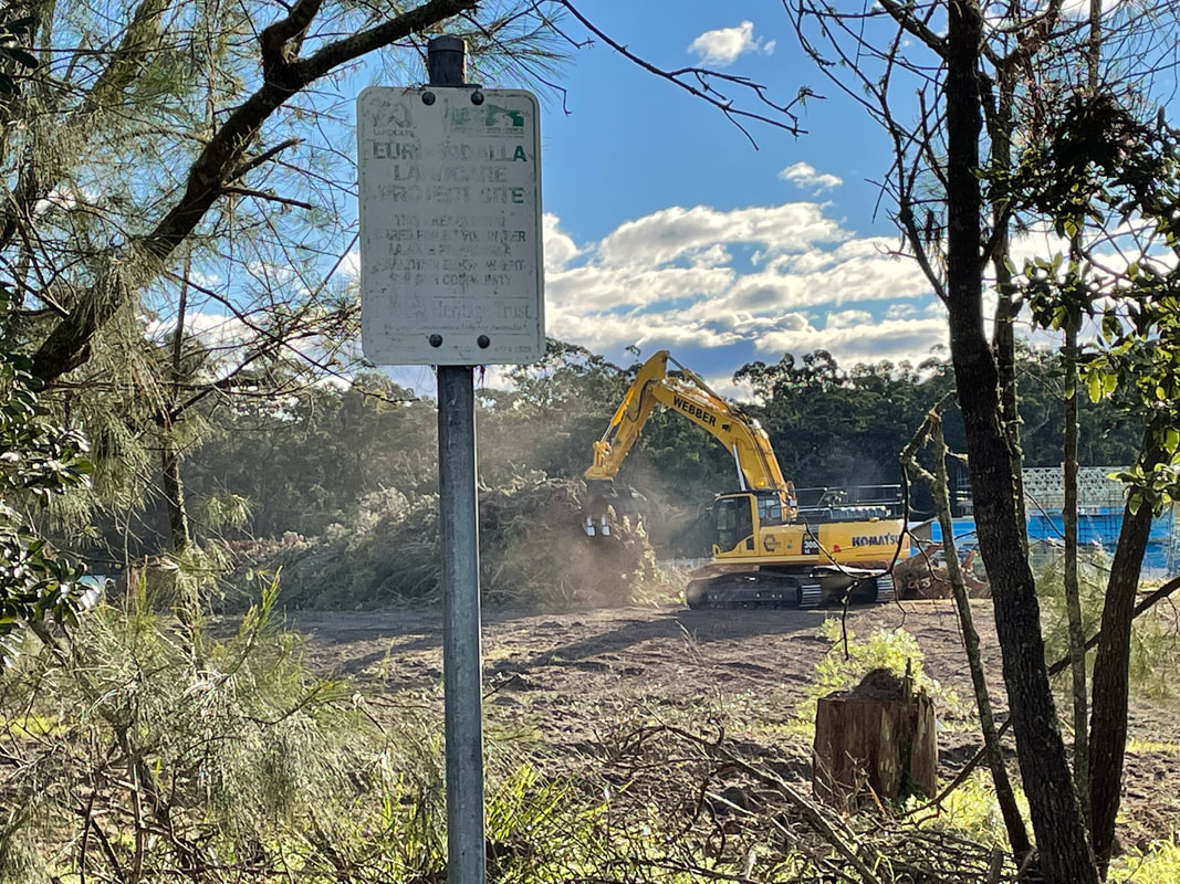
The attached document is the letter we received fro Council confirming that the land on the corner of Broulee Rd and Clarke St is community land and as such is not being considered for development at this time.

"A search of Council records has revealed the Council resolution from 25 November 2003 for these parcels to be classified as Community Land. This classification was not reflected in Council's database of land classification.

Council had been considering the use of this land in the belief it was operational land but its use is no longer under consideration given the above confirmation that it is community land. Council's database is being amended accordingly"

The full letter can be downloaded below:
community_land..pdf
File Size: 252 kb
File Type: pdf
Download File

0 Comments

MINUTES OF QUARTERLY MEETING - 13 MAY 2021

29/5/2021

0 Comments

 
BROULEE MOSSY POINT COMMUNITY ASSOCIATION
MINUTES OF QUARTERLY MEETING
13 MAY 2021

Present:
27 people as per attendance sheet

Apologies:
Barb Roberts, Anthony Mayne, Stewart & DIdi Needham, Simon Lowth, June Carter, Mike & Meg Smith, Elaine Anderson, Cathy Lawarik, Trish Eccles, Victoria Fleming, John Marlton, Gabrielle Wildman, Shane O’Keefe, Vince Fisher

Confirmation of Previous Minutes (13 February 2020)
Acting President apologised for delay in holding meeting but Covid 19 restrictions precluded such an event in 2020 and early 2021 as the school was not available and Council placed restrictions on use of Captain Oldrey Park hall as BMPCA does not not public liability insurance.
Acceptance moved Andrew Bain, seconded Ross Hayward. Agreed

Matters Arising from Minutes
  1. Bay to Breakers swim held on 8 March 2020. BMPCA had limited participation in 2021 because of Covid implications for most volunteers. However BBSLSC made donation of $1000 in light of our past 9 years involvement and hopes that BMPCA can recommence involvement in 2022.
  2. Sandcastle event now being organised by Broulee Surf School, which has always carried insurance for the event.
  3. Art on the Path has now been changed and will be part of the River of Art and will be held at various venues throughout the Shire. It will be held in Broulee in October 2021.
  4. Paver fund raiser for path on western side of Grant Street, has had limited success.
  5. Better Eurobodalla campaign to encourage non-resident ratepayers to register to vote in Council elections in September 2021. Registration forms are available for download from A Better Eurobodalla website. Council has advised that it will be circulating registration forms to non-resident ratepayers shortly.
  6. “Lake Broulee” continues as a problem. No parking zone at North Broulee repainted.

Treasurer’s Report
Little change over past year:
General Account:    $6105.44. Fees not collected last year, membership fees of $10/person are now due. Please put your name on the bank credit.
Pathway Account:    $10,577.00 Includes paver payments, BBSLSC donation.
Acceptance moved Lindsay Boyton, seconded Bill Platts. Agreed

General Business
The items reflect the matters raised by BMPCA Executive in meeting with Eurobodalla Shire Council on 27 April 2021

1. Proposed sale of Community Land at Corner of Broulee Road and Clarke Street
  • BMPCA has since written to Council requesting details of the exact status of the Community Land which it maintains is Operational Land and can be sold.
  • Suggestion that matter be placed on Question without notice to Council
  • Question raised whether this sale is linked to proposed subdivision changes which show a road link to Clarke Street.
2. Proposed Clarke Street access road from Broulee subdivision
  • Bushfire guidelines were changed in 2018 and suggest that dead end roads are not permissible. These guidelines have a degree of flexibility and many innovative options need to be considered.
  • Broulee Development Master Plan was approved in 2016 and shows subdivision road linking Broulee Road closer to George Bass Drive. However, at this stage it could only be a single lane road. This is still access.
  • Questions raised about what recent traffic and bushfire studies have been carried out, particularly after significant changes that have occurred including greater traffic loads from new development. Elizabeth Drive/ Clarke Street has become a rat run to avoid speed restrictions on Train Street and George Bass Drive.
  • It may be wise to readvertise the Broulee Development Master Plan. Many issues are now coming to a head and BMPCA needs answers as soon as possible.
  • Council to be invited to discuss these matters with the community.
3. Broulee Fire Shed Path and extension to Bengello Forest Path
  • The shared pathway will start in the forest at McNee/Grant Street intersection and head west towards the Fire Shed then to Canoe Tree on George Bass Drive, east again towards main power line and then through to Bengello Track. It makes use of existing tracks with minimal upgrades to more solid gravel and would provide a low impact walking/cycling route for community. It also reinforces the Fire Shed as a community hub. This issue was raised by RFS in its post fire presentation to BMPCA in February 2020. Warren Sharpe (ESC) has committed to walk proposed 3km path with BMPCA.
  • This pathway will become a BMPCA priority for next fund raising.
  • It was pointed out that the Fire Shed could become a village resilience hub. This idea is one of the recommendations from the Bushfire Royal Commission.
4. Land Sale on corner of George Bass Drive and Annetts Parade, Mossy Point.
  • Council did not respond to questions about any development.
  • Linda Chapman was invited to provide an outline of the proposal for the community to buy this strategic parcel of land. This 2.06ha is an important parcel of land for connectivity with endangered flora and fauna and even moreso after the bushfires. The purchase is being discussed with WWF, which may be able to provide substantial support. Advertising on Facebook and a website will be launched in week starting 17 May.
5. Polluted Stormwater draining onto South Broulee beach
  • Council has disputed the long term impact of such pollution and would not canvas erection of a sign warning beach goers that the water may be polluted. It advised that it could not reduce the water flow. It carries out water quality monitoring of the beach in summer but refuses to monitor the drain.
  • Considerable discussion ensued about water flow from the drain which has been continuous since heavy rain earlier in the year. It was polluted with raw sewage for 3-4 weeks before Council took action to ameliorate the problem and close the beach.
  • It is the busiest beach in the Shire and marketed as a tourist attraction.
  • BMPCA to investigate costs of monitoring the drain over a year and put a proposal to Council.
6. Road Safety in and around Broulee and Mossy Point
  • Council acknowledged the petition from Mossy Point residents and supported by BMPCA to reduce the speed limit in the villages to 40 km/hour. But remains unmoved on the matter.
  • Council advised that George Bass Drive will be reduced to 80 km/hour in the near future.
  • Suggestion that Heath Street from Grant Street to the Surf Club within Broulee should be considered as a minimum
7. Construction of pedestrian path from Heath Street to the Broulee Post Office
  • Council advised that it was not a priority. It’s current priority is to extend the Mossy Point pathway towards George Bass Drive.
  • The current purchased pavers will be placed around the seat at the corner of Heath and Grant Streets.
8. ESC 21/22 Operational Plan
  • Plan is available on ESC website. Comments are due on 25 May.
  • Suggestion that both stormwater and sewerage issues and pathways be raised.
9. Improvement of aesthetics around Broulee shopping precinct.
  • Community suggestion that Vinnies bin and some landscaping required in precinct.
  • Movement of bin is not favoured by Vinnies nor Real Estate. Approval for it’s location (on privately owned land) was from the late Ian Fraser. It will remain as is.
  • Landscaping is restricted to low growing plants and a planting north of the bus stop will be trialled.

Other Business
  1. Path from Mossy Point Headland to Candlagan Creek. Path is badly eroded, slippery and dangerous for users. Remediation is needed and some time ago a stairway was proposed. This would be a good solution to a well used path.
  2. Multitude of rabbits at Mossy Point particularly near path down to Candlagan Creek. BMPCA to discuss possible blitz in area with Pest Species Officer, Paul Martin.
  3. Noise pollution from low flying jet. Some residents believe that it affects the amenity of the area. We need to be aware that we live near an airport. There is an Air Services classification “fly friendly restrictive zone” which may be relevant.

Next Meeting
September 2021. Kelwyn White (RFS) will be asked to address the meeting on bushfire readiness, use of the Fire Shed for community gatherings, possible resilience centre and proposed pathway interaction.


0 Comments

Council staff meeting Notes

7/5/2021

0 Comments


Meeting Notes regarding the BMPCA / Council staff meeting on 27 April 2021


Notes and agenda for meeting between Council staff and Broulee Mossy Point Community Association (BMPCA).

1. Use of the community building at Captain Oldrey Park for BMPCA meetings.
  • BMPCA provides an important community service but is banned from using the building because it cannot afford public liability insurance. We recognize the need for insurance for sporting bodies and the like but it seems unnecessary for a group that will sit around a table to work on improving and maintaining community facilities in Broulee and Mossy Point. We understand the building is used for private activities without this requirement.
  • We seek Council to remove the insurance requirement for BMPCA meetings.
Discussion
BMPCA thought it was unreasonable for a community group to not be able to use a community building to which they contributed.
Councils insurance does not cover Council for use of the building by an incorporated body.
Decision.
  • Council will continue to require incorporated groups to carry their own insurance.
  • Warren Sharp will inquire with other community groups as to how they meet this requirement.

2. Polluted water draining into South Broulee Beach.
  • South Broulee beach is one of Eurobodalla’s most popular beaches. It is patrolled in summer, has relatively safe surf and is protected from prevailing summer NE wind. The storm water drain crossing the beach now flows much more often, it carries polluted water and recently sewage. This recent sewage flow continued for many days before a notice was erected warning the public.
  • Council planning and engineering decisions have been increasing the frequency of polluted water flows across the beach.
  • We seek a decision by Council to explore the possible use of infiltration ponds to reduce the frequency of flows across the beach. We also seek future sewerage planning to minimize the possibility of sewerage flows across the beach.

Discussion
Council acknowledged that the drain was an unfortunate necessity and would probably get worse as Broulee development continued. It was made clear that sewerage leaks into the water were rare and that the Broulee sewerage infrastructure was maintained in a good condition. It was also acknowledged that the water was probably lightly polluted at all times. Council initially claimed that it would be too expensive to include the drain in the Beachwatch program. BMPCA asked that it be included for at least a few months so a better understanding of the water quality in the drain could be obtained. BMPCA raised the possibility of a sign on the drain warning that the water in the drain may be polluted. Council claimed that any sign would be vandalized.
Decision
No decision was made to test the water or to erect a sign

3. Council response to road safety submissions Broulee village, Annetts Parade Mossy Point, Broulee headland.

  • NSW government says that reducing the speed limit in areas where pedestrians are using roads reduces the probability of accidental death by 50 percent. There are many roads within the villages of Broulee and Mossy Point where this risk reduction to 40Kph would seem to be justified.
  • We seek a review of road safety in Broulee Mossy Point particularly where there is considerable interaction between traffic and pedestrians.
Discussion
Council said that speed limits were not the responsibility of Council.
Council acknowledge the link between speed and pedestrian deaths on joint user roads but considered that speeds on most roads within Broulee were reasonable.
Decision.
Council would not promote any changes but may consider the speeds on Heath Street on the South side of Grant Street.

4. Offsets arrangements for the land between Broulee and the airport and protection from weed infestation.

  • Council allowed the developers of Broulee land to use Council land as an offset. Has there been money paid by developers to improve the environmental condition of the offset land? If so, what work has been undertaken.
  • There is increasing weed infestation along the areas regularly mowed. Is the mowing contractor require to clean the mowing equipment before entering the offset area?
Discussion
The offset fund held by Government has not yet reached 80 percent therefore no money is flowing from this fund. Council does require that the mower operator clean the machine between some sites. It was noted that there was a 4WD barrier that is broken within the protected land that despite advising Council has not yet repaired.
Decision
If BMPCA informs the Council of sites where a problem is developing Council will ensure that cleaning happens before the mower enters these sites.
The barrier will be repaired

5. Construction of a pedestrian path from Heath Street to the Broulee Post Office.

  • There has been significant pressure, particularly from Banksia Village for the construction of a safe path to avoid two road crossings.  We have raised limited funds to contribute to this path but we doubt if more will be possible.
  • Could Council meet the aged community’s need for this path with a cheaper gravel path

Discussion
BMPCA funds are not sufficient to give priority for this path. It would be appropriate for the BMPCA to make a further submission on paths in Broulee to the Councils financial program for 21/22

6. Construction of a joint user gravel path from the Grant Street at McNee street corner to the Canoe Tree. And then to the Bengello path.

  • We would like Council to consider construction of this gravel path as a community asset with tourism, health and fire protection benefits.
  • This would provide a safe and very attractive 3 km path for cyclists, walkers and joggers at small cost as most of the path already exists. BMPCA made an earlier submission about this but was advised that funds were not available.
  • Is there any possibility of seeking grant money for this development?
Discussion
Little discussion apart from mentioning that at times there was appropriate material available from other work carried out by Council.
Decision
Warren Sharpe will walk the track with BMPCA in the near future to gain a better understanding of what would be required.

7. Community consultation on the erection of new signs and the impact on local residents.
  • BMPCA has had complaints that new signs have been erected without consideration of the impact of increased parking and traffic flows on local residents and the natural environment. With caravans and motor homes becoming larger and more popular there have been instances of vehicle entrapment.

Discussion
There was acknowledged that signs have create increased traffic flow without consideration of the oimpact on local residents.

8. Broulee Development – possible new access to Clark Street.
It was agreed to establish a separate meeting with an officer from the planning area of Council to address this
.
9. Voting Arrangements for non-resident ratepayers
The Council said they were sending material to all non-resident ratepayers.

10. Sale of land at the intersection of Broulee Road and Clarke Street
Council claimed that the land was always Operational Land but BMPCA recalled that it was changed to Community land some 15 years ago. This will need to be established.
Additional note: There appears to have been a Council decision on 27 November 2003 to change the land classification from Operational to Community Land. No revocation of this decision could be found. The Natural Heritage Trust sign on the land would also suggest that the land was Community Land as the NHT did not usually fund projects on Operational Land.

11. Sale of land in Annetts Parade.
Council will check the appropriateness of the existing driveway with regard to steepness and proximity to George Bass Drive. Regarding the possible use of Offsets held may hold, the Council did acknowledge that there were excess offsets available to Council.

0 Comments
<<Previous

    Archives

    February 2022
    September 2021
    July 2021
    June 2021
    May 2021
    July 2020
    April 2020
    December 2019
    November 2019
    September 2019
    March 2019
    December 2018
    October 2018
    May 2018
    February 2018
    October 2017
    September 2017
    July 2017
    March 2017
    January 2017
    October 2016
    July 2016
    June 2016
    May 2016
    March 2016
    December 2015
    November 2015
    October 2015
    September 2015
    August 2015
    July 2015
    June 2015
    May 2015
    February 2015
    December 2014
    November 2014
    September 2014
    June 2014
    February 2014
    January 2014
    December 2013
    November 2013
    October 2013
    September 2013
    August 2013
    May 2013

    Categories

    All
    Minutes

    RSS Feed

Proudly powered by Weebly